Robert Moses, the “master builder,” constructed 627 miles of highways in and around New York City during a roughly 40-year period. Many of his projects divided close-knit neighborhoods, demolished viable housing, relocated the poorest New Yorkers to the city’s edge and promoted flight to the suburbs. Now the Sheridan Expressway, a 1.25-mile Bronx segment of his legacy, is slated for a $245 million reconstruction by the New York State Department of Transportation, and locals are fighting back with a plan of their own.
Their plan includes tearing the highway down, and would add the Bronx to a growing list of communities worldwide that are removing roads in the name of urban revitalization, open space, and waterfront access.
Over the past five years an effort by community groups, residents, and regional planning organizations has pressed the New York State Department of Transportation to study an alternative plan for the roadway – one that would remove it altogether in favor of riverfront open space and other possible uses.

The "Community Plan" for the Sheridan Expressway
The proposal, crafted by the Southern Bronx River Watershed Alliance, was recently accepted by the Department of Transportation as one alternative in the Environmental Impact Statement for the project. “Decommissioning the Sheridan would bring the Moses effect full circle,” said Alexie Torres-Fleming, Executive Director of the Bronx community group Youth Ministries for Peace and Justice. “We’re looking for a major project that reconnects neighborhoods, uncovers the area’s natural resources, and addresses one of its biggest transportation problems.”
Sheridan History
Some of the South Bronx’ most distinguishing elements are its highways – miles and miles built during the 1950s and 60s. The Cross Bronx began construction in 1948, the Major Deegan in 1950, the Bruckner in 1957. The last of the South Bronx expressways, the Sheridan, was begun in 1958.
These roads evicted many long-time residents, cut through vibrant districts and created corridors of blight that walled off neighborhoods. At the same time, numerous high-rise public housing projects were developed and the South Bronx was rapidly transformed into one of the city’s poorest areas. “The South Bronx became a dumping ground for the city’s environmental burdens. The land is overrun with power plants, waste transfer stations and toxic industry and is bisected by highways,” said Christina Hemphill of the New York City Environmental Justice Alliance.
As Moses’ power waned, neighborhoods and institutions north of the Cross-Bronx Expressway were able to stop construction of the Sheridan’s second phase. The four-mile extension would have brought the highway through Bronx Park to connect with I-95. Governor Nelson Rockefeller officially killed the project in 1971.
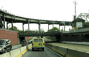
The short section of the Sheridan that was built runs for only a mile and a quarter between the Bruckner and Cross Bronx Expressways. Its four lanes carry 40,000 vehicles per day, approximately one-fifth the volume of traffic on other nearby highways. The New York Post has called the short strip of road a “highway to nowhere.”
The Sheridan Neighborhood
|
The Sheridan Expressway today |
The Sheridan Expressway cuts through largely Hispanic and African American neighborhoods, separating them from each other and the Bronx River. The area has significantly lower than average household income and car ownership rates. It also has some of the highest asthma rates in the entire state. South Bronx neighborhoods have twice the average asthma hospitalization rate of New York City, and 10 times the state rate. Sheridan area neighborhoods are also sorely lacking in open space, with less than 1/2 acre per 1,000 residents – approximately 10 percent of the national average.
Yet the South Bronx also features an impressive density of competent and highly committed community activists. Groups like Sustainable South Bronx, Youth Ministries for Peace and Justice, Mothers on the Move, Nos Quedamos/We Stay and The Point have demanded and begun to win better housing, traffic safety measures, and greenway projects. They are also mobilizing local residents around the community plan for the Sheridan.
“Before public hearings this March, we collected over 700 petition signatures from Hunts Point residents alone against reconstructing the Sheridan,” said Manuela Arciniegas of Sustainable South Bronx. “Our plan serves the business community and the permanent residents of our area. It creates opportunities for positive development.”
The Transportation Department’s Plan
In 1997, the Department of Transportation unveiled plans for a $245 million reconstruction of the connection between the Bruckner and Sheridan expressways, including the construction of new ramps to bring trucks that drive on the Sheridan closer to the Hunts Point Market, a 60-acre wholesale food market that distributes food to grocery stores in New York and New Jersey. The department also said that the project would improve safety and alleviate congestion.
The Tri-State Transportation Campaign, a transportation agency watchdog group where I work as a planner, has questioned the the utility of a multi-million reconstruction of the roadway since the Department of Transportation first released its plans. As one small highway within an overbuilt South Bronx road network, few vehicles use the Sheridan and it is generally considered redundant. The Cross-Bronx, the Major Deegan, and the Bruckner already meet at two other points, and are also connected by the Bronx River Parkway.
In addition, building new ramps to bring trucks closer to the market would further isolate the neighborhood of Hunts Point from the rest of the Bronx, and cast shadows on a nearby park that is under construction.
The Community Plan
In a major victory for Bronx residents, the Department of Transportation has recently agreed to study the Southern Bronx River Watershed Alliance’s “Community Plan” alongside their original plans for the roadway. The "Community Plan" would instead use the 1.25-mile, 28-acre highway for open space as part of the Bronx River Greenway, a bike/pedestrian pathway and park planned for the entire 23-mile length of the Bronx River. “We live in the community 24 hours a day. DOT doesn’t live here, the engineers don’t live here,” explained Francisco Perez of Mothers on the Move. “But because we are black, Hispanic and poor, other people make decisions for us. It’s time for us to make our own decisions.”
The plan also would make it easier for trucks to access the Hunts Point Market, with new entrance and exit ramps off the Bruckner Expressway at Leggett Avenue. Few trucks are even using the Sheridan to get to the market, said Joan Byron of the Pratt Institute, another member of the Southern Bronx River Watershed Alliance. “Eighty percent of truckers to Hunts Point already use the Bruckner for part of their trip to or from the market. And a largely industrial route from the Leggett exit to the market is available and preferable to present routes.” A Department of Transportation survey of truckers found that only 15 percent use the Sheridan to access the market, and only 5 percent used it to exit.
A third component would elevate the Bruckner Expressway over the Bronx River. Currently drivers on the elevated Bruckner Expressway must merge with Bruckner Boulevard (running beneath the expressway) to take a single bridge over the river -- a frequent source of bottlenecks. Elevating the express lanes would create space for bike and pedestrian lanes and allow the reopening of cross streets east and west of the river that are now blocked by the expressway.
If the "Community Plan" were implemented, safety and congestion problems at the Bruckner/Sheridan interchange would disappear along with the interchange itself. If the Sheridan were eliminated, it would also get rid of a frequent source of congestion along the Cross-Bronx. The new Bruckner exit at Leggett Avenue would improve access to the Hunt’s Point Market and keep truck traffic off of from residential blocks.
Other Highway Removal Projects
If the Sheridan is dug up, it will join a growing list of highways being removed by major cities. Waterfront highways have already been eliminated in San Francisco, Portland and Toronto. A similar project was just approved in Seoul, South Korea and Milwaukee, Wisconsin will soon finish its demolition of a downtown freeway.
Milwaukee’s Park East Freeway will give way to parkland, an entertainment complex and new office, retail and residential construction. It shares remarkable similarities with the Sheridan. Community groups stopped the construction of the Park East in the mid-1970s, and the road only stretches one mile long. The road was underutilized and a blight to the community, and when the area around the highway stump began to revitalize in the 1990s, community leaders agreed to remove the highway and help spur the neighborhood’s continued growth. That agreement was reached in 1999, and the $50 million demolition began in 2002.
Next Steps
These examples prove that road removal is viable in major urban areas, but will the Department of Transportation follow suit? The State Department of Transportation recently began its environmental impact study for the Sheridan. It will examine the impacts of the department’s original ideas for a rebuilt interchange, as well as decommissioning the Sheridan.
While the draft environmental impact statement won’t be published for two years, the Southern Bronx River Watershed Alliance still has hurdles ahead. One challenge includes convincing companies at Hunts Point Market that the community's plan will make transportation better for them rather than more difficult. Government officials will need similar convincing. The Department of Transportation will be reluctant to give up highway capacity and as in so many areas, the ultimate decision makers are the governor and the mayor. Winning their attention, with the help of local elected leaders, may be the biggest challenge of all. “There are few things New York politicians fear more than being blamed for making traffic worse,” said the Tri-State Transportation Campaign’s Jon Orcutt.
“If the community alternative for the Sheridan seems radical, it’s because for fifty years, we have allowed highway engineers to be the primary shapers of huge parts of our cities, and allowed the movement of vehicles to trump all other considerations of urban design, public health and safety, and environmental quality,” said Byron.
Danielle Burger is the New York City planner at Tri-State Transportation Campaign, an alliance of regional transportation experts, planning organizations and environmental groups working to improve transportation throughout the metropolitan region. Tri-State is also a member of the Southern Bronx River Watershed Alliance.
* * * * * * * * * *
RELATED ARTICLE: The Power Broker Revisited
* * * * * * * * * *
